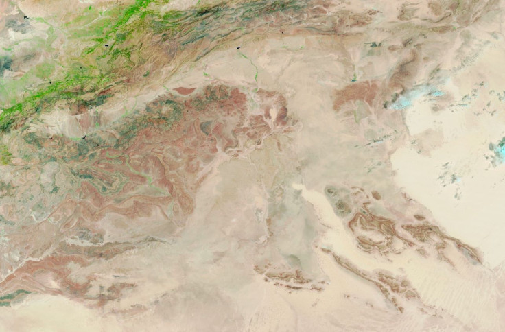
The Sahara Desert, one of the driest places on Earth, is experiencing a remarkable transformation due to recent heavy rainfall. Following an extratropical cyclone that impacted parts of northwestern Africa on September 7 and 8, satellite images from NASA reveal surprising patches of greenery in regions usually characterized by barrenness.
Emergence of Vegetation
Countries such as Morocco, Algeria, Tunisia, and Libya are showcasing new traces of vegetation, with shrubs and trees sprouting in low-lying areas like riverbeds. Historically, the Sahara was a lush environment filled with lakes, but climatic changes have drastically altered this landscape.
Climate Change and Rainfall Patterns
The unusual rainfall event has been attributed to a shift in the tropical rain belt, prompting questions about the effects of climate change on rainfall patterns across Africa. Sylwia Trzaska, a climate variability researcher at the Columbia Climate School, noted that shrubs and trees are thriving in low-lying regions due to this newfound moisture.
Quick Responses to Rainfall
Peter de Menocal, president of the Woods Hole Oceanographic Institution, explained that while such rainfall events are uncommon, plant life in this part of Africa can respond rapidly. During significant rain episodes, arid dunes can transform into lush green expanses as plants take advantage of the moisture.
Historical Context
Historically, the Sahara was once a verdant landscape dotted with vegetation and lakes, a reality that existed between 11,000 and 5,000 years ago, as suggested by de Menocal’s past research. The recent deluge has caused typically dry lakes to fill, as noted by Moshe Armon, a lecturer at the Institute of Earth Sciences, Hebrew University of Jerusalem.
Satellite Observations
On September 10, the Moderate Resolution Imaging Spectroradiometer (MODIS) on NASA’s Terra satellite captured striking false-color images of runoff and floodwater in the Sahara. These images, combining visible and infrared light, show areas covered by water appearing in varying shades of dark and light blue, indicating the depth of the water and the amount of suspended sediment.
Comparison with Previous Conditions
Remarkably, the same region was dry and arid in images captured just a month earlier on August 14. Preliminary satellite analysis suggests that over 200 millimeters of rainfall fell in the affected areas, equivalent to the region’s annual precipitation. These estimates are based on NASA’s Integrated Multi-Satellite Retrievals for GPM (IMERG) data, which is crucial due to the scarcity of ground-based rain gauges and radar stations.
Conclusion
Armon highlighted the extraordinary sight of normally dry lakes filling up as a result of this rainfall event. Satellite images reveal several lakes, including notable locations like Iriqui National Park in Morocco and Sebkha el Melah, a salt flat in central Algeria, now visible as dark blue areas.
Multiple-Choice Questions (MCQs):
- What recent event contributed to the transformation of the Sahara Desert?
- A) A volcanic eruption
- B) An extratropical cyclone
- C) An earthquake
- D) A tsunami
Answer: B) An extratropical cyclone
- Which countries are showcasing new traces of vegetation due to the recent rainfall?
- A) Egypt and Sudan
- B) Morocco, Algeria, Tunisia, and Libya
- C) Chad and Niger
- D) Mali and Mauritania
Answer: B) Morocco, Algeria, Tunisia, and Libya
- What historical feature characterized the Sahara Desert thousands of years ago?
- A) Desert dunes
- B) Forests
- C) Lakes and vegetation
- D) Mountains
Answer: C) Lakes and vegetation
- What tool did NASA use to capture images of the floodwater in the Sahara?
- A) Hubble Space Telescope
- B) The Moderate Resolution Imaging Spectroradiometer (MODIS)
- C) Voyager 1
- D) The Lunar Reconnaissance Orbiter
Answer: B) The Moderate Resolution Imaging Spectroradiometer (MODIS)
- How much rainfall is estimated to have fallen in the affected areas during this event?
- A) 100 millimeters
- B) 150 millimeters
- C) 200 millimeters
- D) 250 millimeters
Answer: C) 200 millimeters
