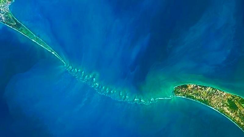
Scientists from the Indian Space Research Organisation (ISRO) have achieved a significant milestone by mapping the submerged structure of Adam’s Bridge, also known as Ram Setu. This ancient bridge, mentioned in Indian religious texts, connects India and Sri Lanka.
Details of the Mapping Project
- Precision Mapping: Using NASA’s ICESat-2 data from October 2018 to October 2023, ISRO created the most detailed undersea map of Adam’s Bridge. The map has a 10-meter resolution, which is precise enough to capture details as small as a train coach.
- Continuity of the Bridge: The map confirms the bridge’s continuity from Dhanushkodi in India to Talaimannar in Sri Lanka. Remarkably, 99.98% of the structure is submerged in shallow waters.
Technological Insights
- Advanced Laser Technology: The researchers utilized advanced laser technology from NASA’s ICESat-2 satellite. The green laser was capable of penetrating up to 40 meters deep, enabling the creation of a high-resolution map of the submerged ridge.
- Discovery of Channels: The team, led by Giribabu Dandabathula, identified 11 narrow channels that facilitate water flow between the Gulf of Mannar and Palk Strait. These channels have played a crucial role in preserving the structure from sea waves.
Historical and Cultural Significance
- Origins and Naming: The structure was named Adam’s Bridge by an East India Company mapper. In Indian tradition, it is referred to as Ram Setu, mentioned in the Ramayana as a bridge built by Ram’s army to rescue his wife Sita from Sri Lanka.
- Historical References: Persian navigators in the ninth century AD called it Sethu Bandhai, meaning a bridge over the sea. Temple records from Rameswaram indicate the bridge was above sea level until 1480, when a powerful storm demolished it.
Challenges and Previous Observations
The sea in the region is extremely shallow, ranging from one to ten meters deep, complicating navigation and mapping efforts. Earlier satellite observations were limited to the exposed sections of the bridge.
Multiple Choice Questions (MCQs):
- What is the primary technology used by ISRO to map Adam’s Bridge?
- A) Satellite imagery from the Hubble Telescope
- B) ICESat-2 data from NASA
- C) Sonar mapping technology
- D) Infrared scanning
- How much of Adam’s Bridge is submerged according to the detailed underwater map?
- A) 50%
- B) 75%
- C) 99.98%
- D) 100%
- Who led the research team that mapped the submerged ridge?
- A) Ravi Kumar
- B) Arvind Patel
- C) Giribabu Dandabathula
- D) Priya Nair
- What did the green laser from NASA’s ICESat-2 satellite help researchers achieve?
- A) Measure sea currents
- B) Create a high-resolution map up to 40 meters deep
- C) Analyze weather patterns
- D) Detect marine life
- Which historical text describes Ram Setu as a bridge constructed by Ram’s army?
- A) Mahabharata
- B) Vedas
- C) Ramayana
- D) Puranas